
I chanced on one of those things that happen on Facebook, a guy asking his followers
If you cold go on a big adventure, what would it be?
Or something to that effect.
Now I don’t have to think a lot about it – granted, it’s a big world and there’s adventures everywhere, but my first, instinctive response is the usual
From Paris to Shanghai by car, following the Silk Road
If you’re here, you know I love the Silk Road, its history, its stories – going along the old road, driving leisurely in my car, would be a dream come true. Stop to look at the landscape, take a few photos, eat a bite…
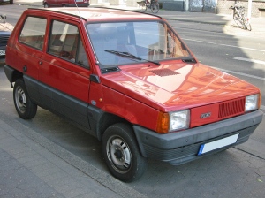 And when I say car, I’d mean my old reliable Panda – a tin can on wheels if ever there was one, so basic and stripped down it did not even come with a radio tuner, but in my experience the best, most reliable, more easily maintained ride I ever had.
But alas, Google Maps at this point lets me down
Sorry, we could not calculate driving directions from “Paris, France” to “Shanghai, China”
But please!
Google can provide me with a flight from Charles Degaulle Airport to Shanghai, for as cheap as 80 euro, but its Maps/Earth tools won’t calculate my route by land.
OK, let’s do it the old way.
What I need are two books: Judy Bonavia’s The Silk Road, Xi’an to Kashgar and Robert Young Pelton’s The World’s Most Dangerous Places.
Now let’s teach Google how it’s done.
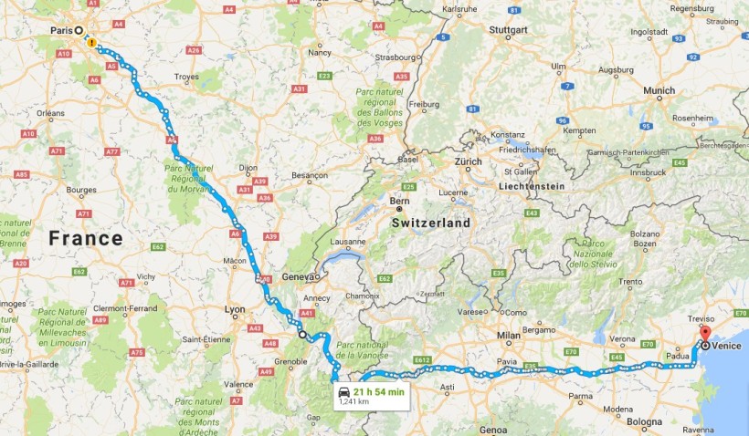
The first leg of the trip – which I am calculating using only secondary roads, no highways, would take me from Paris to Venice, via Chambery, Turin, Milan and Verona. A total of 1300 kms (770 miles) that according to Google I can take in about 22 hours – but hey, that would be non-stop driving.
This route allows me to avoid the Swiss border, sticking to good old EU territories.
Then – Venice to Istanbul.
Another 1300 kms that would take me 30 hours this time, according to Google, a clear sign the roads are a little worse when you get in western Europe. This leg of the trip would see me going through Austria, Slovenia, Austria again, Hungary, Romania, Serbia Romania again, Bulgaria and Turkey.
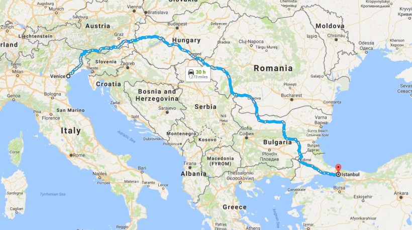
Incidentally, it would be incredibly cool to do the Paris-Istanbul trip on the Orient Express, but we’ll save that one for another time.
Now here the nice part begins, as the obvious route at this point is Istanbul-Kabul via Tehran. You can see now why the Robert Young Pelton book is useful.
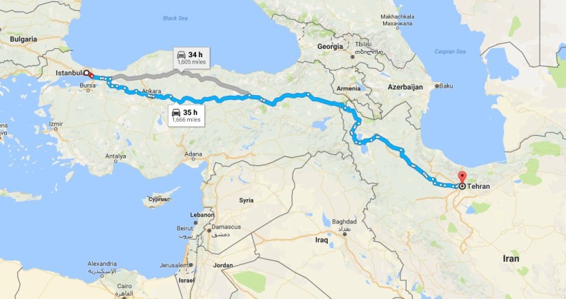
Istanbul to Tehran, via Ankara, is a 1666 miles/2500 Kms trip along country roads and the Turkish massif mountains, taking 35 hours of solid driving. Scenic, but dangerous, and yet not as dangerous as the following leg: Tehran to Kabul means passing through a war-torn landscape, with lots of people wielding Kalashnikovs and convinced they have a good reasons to shoot those Kalashnikovs at us. Not good.

So, let’s try an alternative course: Tehran to Kashgar… which is a problem, because there happen to be two Kashgars, about 600 kms from each other, with mountains between them – Kashgar in Uzbekistan and Kashgan in Xinjiang. And Google is willing to trace my route only to the Uzbek city. Oh, well…
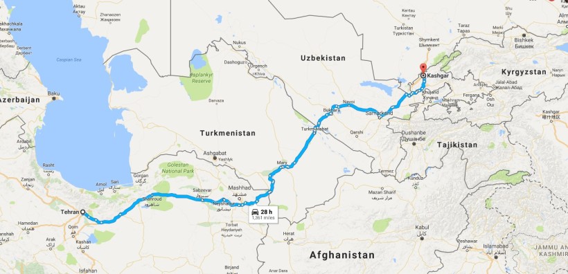
Google therefore takes me north and east, from Tehran to Kashgar in Uzbekistan, a 2200 kms (1350 miles) trip across Turkmenistan and Uzbekistan that is going to take me 28 hours.
And at this point I am alone, because there is no route or connection known to Google Maps from Kashgar in Uzbekistan to Kashgar in Xinjiang.
Nor can I get to Urumqi, that would be another gateway into Xinjiang, and China.
Why is Google Maps acting up?
I have no idea.
And so here I am, after days spent driving through increasingly unknown and possibly hostile land, my poor Panda looks like something that went through a war, I’m tired unshaven and smelling like unwashed laundry, and I can’t get to Xinjiang. Or can I?
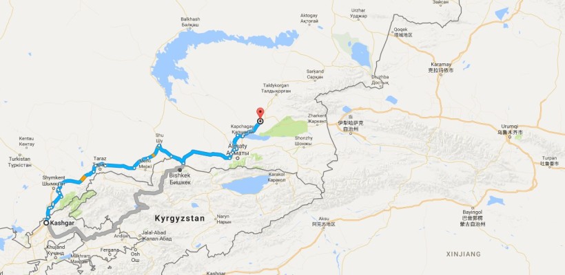
Google allows me to go from Kashgar to Tary, in Kazakhstan.
It’s a 1000 and odd kilometers drive that takes me about 16 hours.
And from Tari to Urumqi there is a frigging road – a highway, as soon as you cross the Chinese border.
But once again, Google Maps refuses to calculate my route.
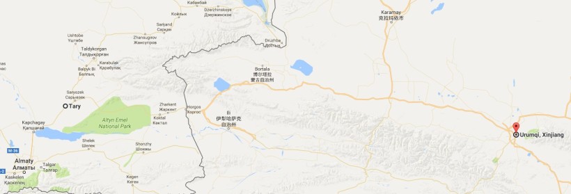
Well, you know what? Screw you, Google Maps – Urumqi, here I come.
It’s more or less another 1000 kms drive.
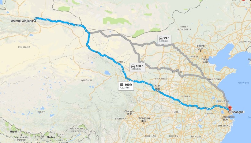
And once you are in Urumqi, it’s all downhill, of course – 4200 kilometers to Shanghai, crossing the width of China. 100 hours of uninterrupted driving along secondary road.
And no problems – probably.
And that’s it, 13500 kilometers, or 8400 miles.
In terms of time, I don’t know – but let’s say an average 500 kms per day, which means a a little less than a month, 27 days.
Doesn’t sound that bad. Marco Polo took a lot longer.
Considering that the ideal fuel consumption of an old Panda was somewhere around 15 kms with 1 litre of gasoline, here we are talking something like 10.000 litres (2650 gallons) of gas.
Once in Shanghai, of course, I could try and sell my Panda for scrap metal, and use the money to buy me a flight back – or maybe… why not find a slow boat crossing the Pacific, and go get a look at those Pre-Colombian things they have in Mexico?
Ah, isn’t dreaming wonderful?

19 April 2017 at 05:27
Always disruptive my friend not to dare say you expand its meaning
LikeLike
19 April 2017 at 11:12
I’m not sure I got your meaning here.
LikeLiked by 1 person
19 April 2017 at 14:30
Reblogged this on Angelo Benuzzi and commented:
You may be cool, but you will never be cool as an adventurer who travels in a FIAT Panda.
LikeLike
22 April 2017 at 09:29
It is a bit odd that Big G let’s you down like that…
I’ve tried with both Here Maps and the good old free OpenStreetMap, and they both are able to calculate the directions (Here also asks me of I go there often 😁)
LikeLike
22 April 2017 at 11:51
It’s probably my connection, that scares G away 😀
LikeLike
19 April 2019 at 17:44
I think Google has a separate system for inside China from outside it (due to their censorship), so it won’t let you do a route that crosses the Chinese border in one go.
LikeLike
19 April 2019 at 19:30
I did not think about that eventuality.
We are so used at open information that… ah!
Good point. Thank you!
LikeLike